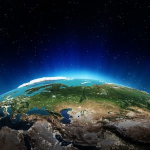
In 2000, Bill Clinton was president of the United States, and the world’s computers had just ‘survived’ the Y2K bug. It was also the year that NASA’s Terra satellite began collecting images of Earth.
 Eighteen years later, Terra – mounted with five scientific sensors – is still in operation. For all of this time, the satellite’s Moderate Resolution Imaging Spectroadiometer – MODIS – has been collecting data and imagery of the Arctic, and the rest of the planet, on a daily basis.
MODIS is a key instrument aboard the Terra (originally known as EOS AM-1) and Aqua (originally known as EOS PM-1) satellites. Terra’s orbit around the Earth is timed so that it passes from north to south across the equator in the morning, while Aqua passes south to north over the equator in the afternoon. Terra MODIS and Aqua MODIS are viewing the entire Earth’s surface every 1 to 2 days, acquiring data in 36 spectral bands, or groups of wavelengths. The data collected will improve our understanding of global dynamics occurring on the land, in the oceans, and in the lower atmosphere. It is playing a vital role in the development of validated global interactive Earth system models able to predict global change accurately enough to assist policy makers in making sound decisions concerning the protection of our environment.
Terra explores the connections between Earth’s atmosphere, land, snow, ice, and the ocean and energy balance to understand Earth’s climate and climate change; and to map the impact of human activity and natural disasters on communities and ecosystems. Since 2003, Terra has maintained a strict equatorial crossing-time within a tight, two-minute window.
Aqua collects data on the Earth’s water cycle, including evaporation from the oceans, water vapor in the atmosphere, clouds, precipitation, soil moisture, sea ice, land ice, and snow cover on the land and ice. Additional variables also being measured by Aqua include radiative energy fluxes, aerosols, vegetation cover on the land, phytoplankton and dissolved organic matter in the oceans, air, land, and water temperatures.
Aqua was launched on May 4, 2002, and has six Earth-observing instruments on board, collecting a variety of global data sets. Aqua was originally developed for a six-year design life but has now far exceeded that original goal.
The images sent back from both Terra and Aqua were once only available on specialized web sites used by scientists, but now the full record of MODIS is available through NASA’s worldview browser. To capture the images, the lenses inside had to manufactured to exact specifications, guaranteeing clarity. At Universe Optics, we design and manufacture precision lens that deliver the quality image required.
With the images collected by Terra, and being able to now view them online, one can scroll back to any date, post 2000, and see what the Earth looked like. It’s fascinating to see how the Earth has changed. This gives scientists the ability to see back in time, and more fully understand the Earth and how it affects life, and be able to predict changes in the future.